We are happy to offer land surveying services. Read about each area of land surveying services below.
Boundary Surveying
- See an ExampleA survey that establishes boundaries of a parcel using its legal description, which typically involves the setting or restoration of monuments or markers at the corners or along the lines of the parcel. Markers set in the ground are generally in the form of rebar, iron rods, pipes, or concrete monuments. PK Nails, Mag Nails or Railroad Spikes are generally set in concrete or asphalt. A legal description may also be required for recording purposes.
FEMA Flood Plain Analysis
- A FEMA flood plain analysis is used to determine whether a particular property, area of a property or structure within the property is located in a flood plain. As FEMA continuously updates their maps more and more property owners are required to pay expensive flood insurance premiums. The different types of FEMA flood plain surveys include:
- Elevation Certificate – Assists in the verification of whether or not there is a need for flood insurance on a particular structure.
- Letter of Map Change (LOMC) – A document issued by FEMA that revise or amend the flood hazard information shown on a FIRM or DFIRM without requiring the FIRM or DFIRM to be physically revised and republished.
- Letter of Map Amendment (LOMA) – An amendment to the currently effective FEMA map which establishes that a property is not located in a Special Flood Hazard Area (SFHA). A LOMA is issued only by FEMA.View LOMA Example
- Letter of Map Revision (LOMR) – An official amendment to the currently effective FEMA map. It is issued by FEMA and changes flood zones, delineations, and elevations.
- Letter of Map Revision based on Fill (LOMAR-F) – A LOMR with the exception that the current grading of the area was altered by bringing in fill. Navigating the entity that is FEMA can be arduous to say the least.
Let Binkley Land Surveying assist you in determining what is the most effective way to meet your needs.
ALTA/ASCM Land Title Survey
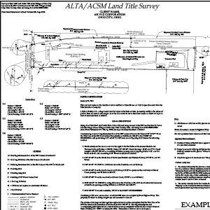 A surveying standard jointly proposed by the American Land Title Association and the American Congress on Surveying and Mapping that incorporates elements of the boundary survey, mortgage survey, and topographic survey. This type of survey is generally prepared for commercial properties and requested by the Title Company and/or lender. Additional requirements in conjunction with the minimum standards may be requested using the optional “Table A” which delineates the work to be performed by the Professional Surveyor.
Mortgage Location Survey
- View an ExampleA Mortgage Location Survey is usually requested by title insurance companies anytime a home is sold or refinanced. This type of survey will show basic information discovered from measurements taken in the field. They are primarily intended to insure the title company and financial lending institutions that the existing improvements are indeed on the property and are not located within existing easements or right-of-ways. A Mortgage Location Survey is NOT a Boundary Survey and it is recommended that you do not construct buildings, fences, landscaping or any improvement from this type of survey.
Lot Splits/Consolidation Surveys
- A lot split is a type of survey used to subdivide an existing parcel of land into multiple parcels while a consolidation survey is used to combine multiple parcels of land into one parcel. Each county, township, or municipality may have different or additional regulations that need to be observed. Aside from relying on your Professional Surveyor it is suggested that property owners check with their respective county, township, and/or municipality to ensure that all guidelines for the proposed lot split or consolidation survey are able to be met.
Topographic Survey
- A survey that measures the elevation of points on a particular piece of land and presents them as contour lines on a plot. This type of survey is generally used to show the existing ground elevations for the purpose of site civil design. It is also used to help determine whether a particular property is located within the flood plain as determined by FEMA.
Construction Staking/Layout
- For general construction purposes this type of surveying service is used in the placement of proposed improvements in accordance with the site development plan. To include, but not limited to: Grade Staking, As-Builts, Earthwork and quantity determinations, or any type of construction activity.
Easement Preparation
- An easement is an interest in land owned by another that entitles its holder to a specific limited use or enjoyment. For example, if a parcel of land is unable to be accessed without crossing over an adjoining property, it may be necessary to create an easement which will allow the owner of the subject property the right to cross the adjoining property. An easement may also be created in order to install utilities, maintain structures, for right-of-way purposes, for the use of a water course, etc.
As Built Surveys
- A survey carried out during or immediately after a construction project for record, completion evaluation and payment purposes. An as-built survey also known as a ‘works as executed survey’ documents the location of the recently constructed elements that are subject to completion evaluation. As built surveys are typically presented in red or redline and overlaid over existing design plans for direct comparison with the design information.
Lot Survey/Plot Plan
- Many municipalities may require a Lot Survey/Plot Plan in order to obtain a ‘Building Permit’. This type of survey is similar to a Mortgage Location Survey but is created specifically for the purpose of constructing improvements on a property. Types of improvements include: New Homes or structures, additions to existing structures, sheds, driveways, decks, fences and invisible fences to name a few.